GOCE for Coastal Ocean DYNamics and geodesy (GOCODYN)
About the project
The GOCODYN project is a continuation and link to former investigations in the frame of the NovaGOCE project realized under Norwegian Research Council's Space research program. GOCODYN represents a collaboration between NMBU and international institutions, i.e., the Bavarian Academy of Sciences and Humanities (Germany) and DTU Space (Denmark), as well as the Norwegian Mapping Authority Kartverket as an external partner.
Specific project objectives and tasks of GOCODYN are:
1. Quality assessments of coastal altimetry products.
2. Quality assessment of the height reference frame in Norway.
3. Determination of an optimal geoid using GOCE and regional geoid grids.
4. Refinement of altimetry products.
5. Investigation on applicability of a geoid based reference frame.
The ocean's MDT represents the surface ocean circulation and can be determined by the methodically different approaches of geodesy and oceanography. The ocean approach implies using numerical ocean circulation models, while the geodetic approach refers to MDT as the height of mean sea surface (MSS) or mean sea level (MSL) above the geoid.
Since GOCODYN's target area is the Norwegian coast, a necessity for GOCODYN is the availability of a regional geoid model, which has been provided by the project partner at the Norwegian Mapping Authority. The current version of this model does not yet take into account the latest release of GOCE products. Therefore, the project requires generating a preliminary geoid, blending the short scales of the regional model with the large-scale information from the latest GOCE release.
The current PhD project of Martina Idžanović is closely related to the PhD work of Vegard Ophaug. He has already provided a preliminary version of a blended geoid and used this for a comparison between geodetic and ocean MDT models along the Norwegian coast in Ophaug et al. (2015). New-generation synthetic aperture radar (SAR) altimetry delivers observations in coastal areas, previously not covered by conventional altimetry. Therefore, the potential of SAR(In) altimetry, implemented on CS2, is highlighted in Idžanović et al. (2016) and Idžanović et al. (2018). The availabilty of new data enabled the improvement of MDT determination along the Norwegian coast and is shown in Idžanović et al. (2017).
An additional focus of the current PhD work is realizing a vertical reference frame (VRF). Thereby, in addition to GOCE, different types of data (GNSS, spirit levelling, tide gauges, terrestrial gravimetry) will be combined and validated against each other. Considering the availability of dens terrestrial gravity data sets, a precise regional geoid model can replace levelling for the definition and realization of vertical reference frames (VRFs).
Aspects of geoid-based VRFs will be investigated considering the special situation in Norway, taking into account both data availability and quality (Gerlach and Ophaug, 2017) as well as time variations of the geoid due to post glacial rebound (Ophaug et al., 2016).
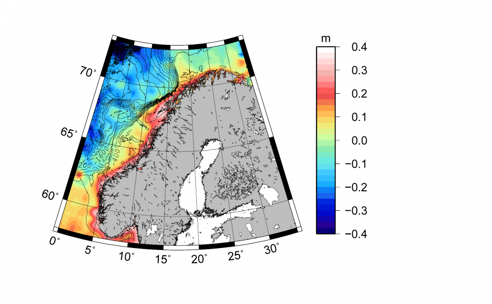
Coastal mean dynamic topography based on CryoSat-2 and NKG2015. The mean value has been removed. 400 m isobaths from the 2014 General Bathymetric Charts of the Oceans (GEBCO) (Weatherall et al., 2015) grid are shown.
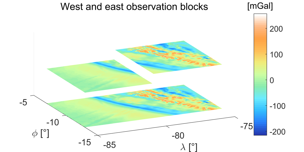
Observation vectors (west and east areas) for each step of stepwise collocation in the study area of the Andes region in South America.
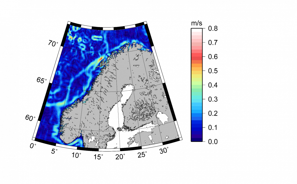
Geostrophic ocean surface currents derived from CryoSat-2 and NMA2014.
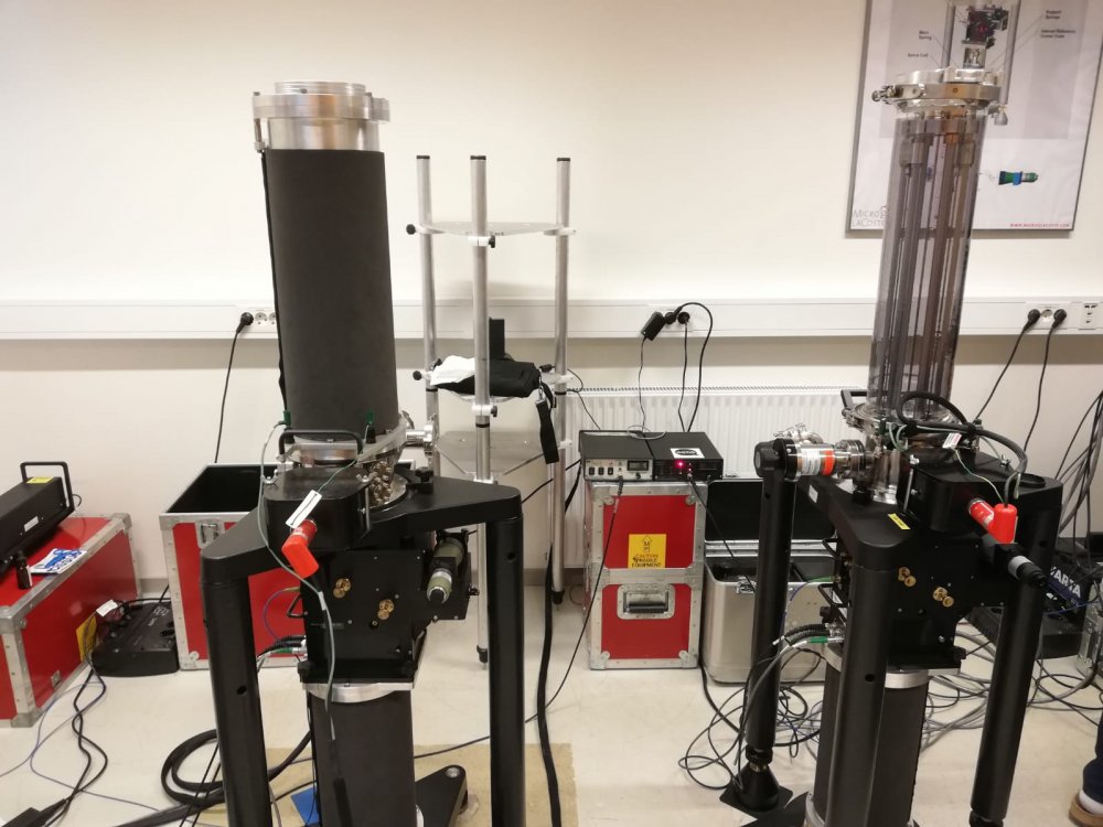
Micro g LaCoste absolute gravimeters FG5 (left) and FG5-X (right) at NMBU's gravity lab.
News / Findings
- Talking with NMBU's rector about one of GOCODYN's research topics
NMBU's rector Mari Sundli Tveit visited the Faculty of Science and Technology (RealTek), where Martina Idžanović presented her latest work on land uplift determination in Norway by combining satellite altimetry and tide-gauge observations. Martina also gave an interview, which you can see here.
- GOCODYN's work as Journal and Editor's highlight in AGU's Geophysical Research Letters
"This paper presents a study on the determination of the mean dynamic topography (MDT) for the period of 2012-2015 around the Norwegian Coastal Current using satellite altimetry data from the CryoSat-2 (CS2) mission and three regional geoid models. The resulting CS2 MDTs are validated by comparing them with an operational coastal numerical ocean model and the MDTs at tide gauges along the Norwegian coast. This paper is timely and important, as the new altimetry improves our ability to observe the ocean closer to the coast." — Editor’s Highlight
- GOCODYN on ESA's web page: CryoSat sets new standard for measuring sea levels
The work of Vegard Ophaug and Martina Idžanović was published on the European Space Agency (ESA) web page, where the potential of the CS2 radar altimeter was pointed out. Its smaller footprint enables sea-level measurements in the coastal zone (see Figure below, giving an example for the Stavanger tide gauge), which is of huge importance for all kinds of offshore activities.

"Scientists from the Norwegian University of Life Sciences also discovered that CryoSat had the potential to map sea level closer to the coast."
— ESA's CryoSat-2 homepage
Events
2018
- Martina had her final seminar on January 26.
2016
- Vegard had his final seminar on November 9.
- Martina had her mid-term seminar on November 9.
2015
- Vegard had his mid-term seminar on September 25.
- Martina had her start-up seminar on September 25.
Results / Publications
Publications:
2019
- Ophaug, V., K. Breili, and O. B. Andersen (2019), A coastal mean sea surface with associated errors in Norway based on new-generation altimetry, Adv. Space Res., in press, doi: 10.1016/j.asr.2019.08.010.
- Gerlach, Ch., V. Ophaug, O. C. D. Omang, and M. Idžanović (2019), Quality and Distribution of Terrestrial Gravity Data for Precise Regional Geoid Modeling: A Generalized Setup. In: International Association of Geodesy Symposia, Springer, Berlin, Heidelberg, doi: 10.1007/1345_2019_71.
- Idžanović, M., C. Gerlach, K. Breili, and O. B. Andersen (2019), An Attempt to Observe Vertical Land Motion along the Norwegian Coast by CryoSat-2 and Tide Gauges, Remote Sens., 11(7), 744, doi: 10.3390/rs11070744.
2018
- Idžanović, M., V. Ophaug, and O. B. Andersen (2018), Coastal sea level from CryoSat-2 SARIn altimetry in Norway, Adv. Space Res., 62(6), 1344–1357, doi: 10.1016/j.asr.2017.07.043.
- Idžanović, M. and Ch. Gerlach (2018), Analysis of Glacial Isostatic Adjustment in Fennoscandia: Comparison of Model Results and Observational Evidence, avn, 125(7), 230–243, External Link.
2017
- Gerlach, C. and V. Ophaug (2017), Accuracy of Regional Geoid Modelling with GOCE, In: Proceedings of the International Association of Geodesy Symposia, pp. 1–7, Springer Berlin Heidelberg, doi: 10.1007/1345_2017_6.
- Idžanović, M., V. Ophaug, and O. B. Andersen (2017), The coastal mean dynamic topography in Norway observed by CryoSat-2 and GOCE, Geophys. Res. Lett., 44(11), 5609–5617, doi: 10.1002/2017GL073777.
- Ophaug, V. and C. Gerlach (2017), On the equivalence of spherical splines with least-squares collocation and Stokes’s formula for regional geoid computation, J. Geod., 91(11), 1367–1382, doi: 10.1007/s00190-017-1030-1.
2016
- Idžanović, M., V. Ophaug, and O. B. Andersen (2016), Coastal sea level in Norway from CryoSat-2 SAR altimetry, In: Proceedings of the 2016 European Space Agency Living Planet Symposium, ESA Special Publication SP-740 on CD-ROM, Prague, Czech Republic, May 9-13, External Link.
- Ophaug, V., K. Breili, C. Gerlach, J. G. O. Gjevestad, D. I. Lysaker, O. C. D. Omang, and B. R. Pettersen (2016), Absolute gravity observations in Norway (1993–2014) for glacial isostatic adjustment studies: The influence of gravitational loading effects on secular gravity trends, J. Geodyn., 102, 83–94, doi: 10.1016/j.jog.2016.09.001.
2015
- Ophaug, V., K. Breili, and C. Gerlach (2015), A comparative assessment of coastal mean dynamic topography in Norway by geodetic and ocean approaches, J. Geophys. Res. Oceans, 120, 7807–7826, doi: 10.1002/2015JC011145.
Talks, posters and conferences:
2018
- Idžanović, M., K. Breili, C. Gerlach, and O. B. Andersen: Land Uplift Determined by Satellite Altimetry and Tide-Gauge Data in Fennoscandia, Poster presented at the "25 Years of Progress in Radar Altimetry" Symposium, September 24-29, Ponta Delgada, São Miguel Island, Azores Archipelago, Portugal.
- Ophaug, V., K. Breili, and O. B. Andersen: A coastal mean sea surface with associated errors in Norway based on new-generation altimetry, Poster presented at the "25 Years of Progress in Radar Altimetry" Symposium, September 24-29, Ponta Delgada, São Miguel Island, Azores Archipelago, Portugal.
- Ophaug, V., M. Idžanović, and O. B. Andersen: The Norwegian Coastal Current observed by CryoSat-2 and GOCE, Talk given at the "25 Years of Progress in Radar Altimetry" Symposium, September 24-29, Ponta Delgada, São Miguel Island, Azores Archipelago, Portugal.
- Gerlach, C., V. Ophaug, O. C. D. Omang, and M. Idžanović: Quality and distribution of terrestrial gravity data for precise regional geoid modeling in a testbed along the Norwegian coast, Poster presented at the Hotine-Marussi Symposium 2018, June 18-22, Rome, Italy.
- Idžanović, M., V. Ophaug, and O. B. Andersen: The Norwegian Coastal Current observed by CryoSat-2 and GOCE, Poster presented at the International review workshop on satellite altimetry CAL/VAL activities and applications, April 23-26, Chania, Crete, Greece.
- Idžanović, M., V. Ophaug, and O. B. Andersen: Coastal Sea Level from CryoSat-2 SARIn Altimetry in Norway, Poster presented at the International review workshop on satellite altimetry CAL/VAL activities and applications, April 23-26, Chania, Crete, Greece.
2017
- Idžanović, M. and C. Gerlach: Comparison of the semi-empirical land uplift model NKG2016LU and GIA-modelled present-day geodetic variations in Fennoscandia based on different ice models, Talk given at the Fall meeting of the German Geophysical Society, October 24-27, Blaibach, Germany.
- Idžanović, M. and C. Gerlach: Comparison of the semi-empirical land uplift model NKG2016LU and GIA-modelled present-day geodetic variations in Fennoscandia based on different ice models, Poster presented at the International workshop on the inter-comparison of space and ground gravity and geometric spatial measurements, October 16-18, Strasbourg, France.
- Andersen, O. B., M. Idžanović, V. Ophaug, and A. Aulaitijiang: The Great Value of Cryosat-2 SAR-in for Coastal Sea Level Monitoring, Talk given at the North-American CryoSat Science Meeting, March 20-24, Banff, Alberta, Canada.
- Idžanović, M., V. Ophaug, and O. B. Andersen: The Norwegian Coastal Current observed by CryoSat-2 and GOCE, Poster presented at the North-American CryoSat Science Meeting, March 20-24, Banff, Alberta, Canada.
- Idžanović, M., V. Ophaug, and O. B. Andersen: The Norwegian Coastal Current observed by CryoSat-2 and GOCE, Poster presented at the 10th Coastal Altimetry Workshop, February 21-24, Florence, Italy.
- Idžanović, M., V. Ophaug, and O. B. Andersen: Coastal Sea Level from CryoSat-2 SARIn Altimetry in Norway, Poster presented at the 10th Coastal Altimetry Workshop, February 21-24, Florence, Italy.
2016
- Nordic Geodetic Commission joint WG workshop on postglacial land uplift modelling, December 1-2, Gävle, Sweden.
- Idžanović, M., V. Ophaug, and O. B. Andersen: The Norwegian Coastal Current observed by CryoSat-2 SARIn altimetry, Poster presented at the 2016 SAR Altimetry Workshop, October 31, La Rochelle, France.
- Gerlach, C. and V. Ophaug: Accuracy of Regional Geoid Modeling with GOCE, Poster presented at the International Symposium on Gravity, Geoid and Height Systems 2016, September 19-23, Thessaloniki, Greece.
- Idžanović, M., V. Ophaug, and O. B. Andersen: The Norwegian Coastal Current observed by CryoSat-2 SARIn altimetry, Poster presented at the International Symposium on Gravity, Geoid and Height Systems 2016, September 19-23, Thessaloniki, Greece.
- Idžanović, M., V. Ophaug, and O. B. Andersen: Coastal Sea Level in Norway from CryoSat-2 SAR Altimetry, Poster presented at the ESA Living Planet Symposium 2016, May 9-13, Prague, Czech Republic.
- Ophaug, V., K. Breili, and C. Gerlach: A comparative assessment of coastal mean dynamic topography in Norway by geodetic and ocean approaches, Talk given at the ESA Living Planet Symposium 2016, May 9-13, Prague, Czech Republic.
- Ophaug, V.: On MDT accuracy in Norway, Talk given at the ESA GOCE++DYCOT First Project Meeting, February 16, Copenhagen, Denmark.
2015
- Glacial Isostatic Adjustment Training School, Ohio State University, September 13-19, Stone Laboratory on Gibralter Island, Lake Erie, USA.
2014
- Ophaug, V., K. Breili, C. Gerlach, C. W. Hughes, and B. R. Pettersen: Mean dynamic topography at Norwegian tide gauges using new GOCE based regional geoid models, Poster presented at the 5th International GOCE User Workshop, November 25-28, Paris, France.
- Breili, K. and V. Ophaug: Assessment of coastal altimetry observations along the Norwegian coast – preliminary results, Poster presented at the 8th Coastal Altimetry Workshop, October 23-24, Lake Constance, Germany.